Restoring habitat for shore-spawning kokanee in Kootenay Lake

Project Year: 2022-2023

Multi-year Project

View Provincial Database Record

Photo: Province of BC

Project Lead

Friends of Kootenay Lake Stewardship Society

Watershed/Sub-region

Columbia Region

West Kootenay

Project Type

Monitoring & Evaluation

FWCP Contribution

$18,070

Action Plan Alignment

Reservoirs & Large Lakes

Project ID

COL-F23-F-3696

Shore Spawning Kokanee Restoration & Research Project Year 3

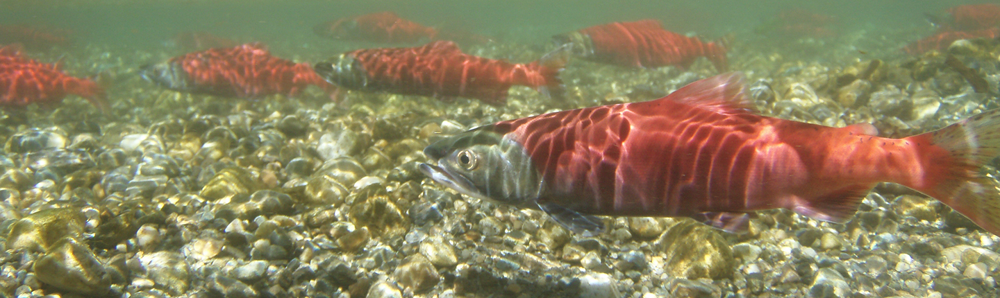
This multi-year project to increase kokanee fry survival focuses on collecting data and restoring habitat for declining shore-spawning kokanee in the West Arm of Kootenay Lake.

In addition, potential sites for future restoration will be identified using on-the-ground monitoring and drone images.


Update: More than 100 m² of kokanee spawning habitat enhanced

To enhance spawning habitat in the West Arm of Kootenay Lake for shore-spawning kokanee, the project provided ideally sized gravel near-shore at a lower elevation to reduce the risk of the redds dewatering.

Other goals achieved included comparing egg-to-fry survival in the new spawning gravel compared to a control area and using novel tools like drone imagery and groundwater measurements to locate other kokanee shore-spawning sites.


Executive Summary

In 2022-23, the Friends of Kootenay Lake conducted post-restoration monitoring, assessments, and habitat research at McDonald’s Landing Regional Park in partnership with the BC Provincial Government and the University of BC Okanagan as part of a multi-year initiative to address the concern of shore-spawning kokanee salmon (SSKS) (Oncorhynchus nerka) redds and fry dewatering with the annual spring drawdown of Kootenay Lake.

In 2020 (year one of the project), 80 cubic metres of gravel was sifted, sorted, and deposited along the foreshore of McDonald’s Landing Regional Park at a known SSKS spawning location in a 50×2 metre strip below the low water mark (LWM). This was done in an attempt to encourage SSKS to spawn below the LWM where redds will not dewater.

In the two years since the gravel installation (2021 and 2022), the Friends of Kootenay Lake and partners monitored spawning kokanee numbers and redd development; examined spatial and temporal variability of near-shore groundwater seepage; assessed gravel morphology and conducted maintenance as needed; compared egg-to-fry survival in the restored substrate below the low water mark to the historical substrate above the low water mark; collected water temperature data; conducted multi-spectral imaging of the spawning habitat; assessed dewatered SSKS redds; and conducted community education and outreach about SSKS in Kootenay Lake.

Results from the third and final year of the project (2022-2023) confirmed and expanded those from previous years. In fall 2022, spawning SSKS were observed in the natural and installed spawning gravel in roughly equal proportions. However, there were more redds above the LWM (77%, n = 50) than below the LWM (23%, n = 15).

In winter 2023, egg-to-fry survival rates of installed triploid kokanee eggs were comparable in the natural gravel above the LWM (33% ± 12.3) and the restored gravel below the LWM (22% ± 7.9). These results suggest that kokanee offspring would not be negatively impacted if deposited below the LWM. Eggs deposited below the LWM would also not dewater in the spring, resulting in a much greater overall survival rate compared to eggs deposited above the LWM. Therefore, kokanee eggs and fry would likely benefit from interventions to keep spawners lower in elevation.

In fall 2022, the majority of redds were formed above the LWM in areas of significant groundwater upwelling, indicating that groundwater is a better predictor of redd development than substrate. Redds contained mostly live kokanee on March 30, 2023, indicating that if there is groundwater flow, kokanee fry can survive multiple weeks above the LWM during the low water period. Aerial photos were found to be useful for identifying areas of worked gravel (and potentially spawning fish, in ideal conditions that allow crisp, non-shadowy images). However, to obtain accurate redd and spawning fish counts, boat surveys would still be required.

Groundwater presence can be seen in the thermal images taken of both the McDonald’s Landing and Bonaventure Lagoon spawning sites on April 6, 2023. Groundwater presence correlated with redd location, confirming that thermal imagery can be used to identify groundwater presence and the probable locations of dewatered SSKS redds. The collected LiDAR imagery, showing the elevational profiles of the two sites, can aid in identifying other probable spawning areas on the West Arm of Kootenay Lake. However, it was too coarse to allow the visual identification of redds from the imagery.

Nearly 60 residents participated directly in outreach activities in year three. Activities included a groundwater study presentation on August 22, 2022, an online project feedback survey released in June, 2022, and a kokanee monitoring workshop delivered on October 15, 2022. Participant feedback was positive and additional engagement with some of the same individuals has occurred. Future engagement is expected as well, as we enter the 2023/4 spawning season. Survey feedback shows that residents support the project and learned more about SSKS through the project. Numerous educational videos, social media posts, funder acknowledgements, and event promotions related to SSKS were released across our various online platforms. The social media posts alone reached 4,630 people between February 2022 and April 2023. We also posted a permanent informational sign about SSKS at the McDonald’s Landing site on January 20, 2023, which was reviewed by fisheries personnel and produced by professional designers and printers.

Recommendations outlined at the end of this report are intended to guide continued SSKS monitoring, assessments, and research on the West Arm of Kootenay Lake. FoKLSS is already applying the findings from the McDonald’s Landing project to the SSKS spawning site at Bonaventure Lagoon. We are currently assessing the feasibility of restoring the lagoon to limit the dewatering of redds by lowering the nearshore elevation and installing gravel. Depending on the findings of the 2023 feasibility assessment, we may conduct a full-scale enhancement of Bonaventure Lagoon in future years.

Click the provincial database link below to read the full final report for this project.

View more about this project on the provincial database