F25 Campbell River Gravel Strategy (Post-Storm Assessment)
The FWCP Coastal Region board approved funds to conduct spawning habitat assessments in the event winter flows exceed 225 cubic metres per second in the lower Campbell River. This aligns with the Campbell River Salmon Spawning Habitat Restoration Strategy.
The study will use methodology developed in 2019 through ongoing FWCP funding. The project will provide a high-level assessment of habitat and determine if work needs to be carried out urgently this summer to provide sufficient Chinook spawning habitat for the fall.
Executive Summary
The lower Campbell River has been strategically supplemented with chinook salmon spawning gravel since the 1990s because of a sediment deficit caused by the John Hart Dam (JHN). This gravel placement is a high priority action as part of the Fish & Wildlife Compensation Program (FWCP) Campbell River Watershed Action Plan.
Following post-storm monitoring in March 2024, A-Tlegay Fisheries Society (A-Tlegay) retained Northwest Hydraulic Consultants Ltd. (NHC) to perform a detailed chinook salmon spawning gravel assessment and hydrotechnical analysis for the lower Campbell River. This report presents the current quality and extents of the spawning gravel, and discussion regarding future monitoring and placement design. This monitoring and evaluation work aligns with action CBR.RLR.ME.23.01 Conduct gravel monitoring in the lower Campbell River-P1 of the FWCP Campbell River Watershed Action Plan. The results of this work indicate a need for gravel placement for spawning salmonids under priority action CBR.RLR.HB.13.01 Gravel placement in the lower Campbell River-P1. This report provides details regarding urgency and recommended timing.
This project of a detailed spawning gravel assessment enabled estimation of specific habitat area quantities and quality of spawning gravel, the degree of erosion in previously surveyed areas, and the apparent urgency of spawning gravel requirements in the lower Campbell River. A comparison to the benefits of rapid spawning gravel assessments was discussed in this report. Rapid assessments are a lower-cost method of determining presence and movement of spawning gravel as well as forecasting needs for future gravel placement projects. The detailed spawning gravel assessments provide additional information on the gravel quality, and more accurate area estimates for spawning habitat.
NHC assessed gravel stability and discussed how different gravel placement methods, such as embedment strategies, could increase gravel retention in future designs. Future studies such as literature reviews of gravel placement projects, including past Campbell River projects, and gravel grain size gradations would provide better insight into stable gravel pad designs. Additionally, a gravel tracing program would help evaluate the threshold for sediment entrainment, transport distances, and deposition locations of spawning gravels under varying
flow conditions.
Previous hydrotechnical analyses identified a discharge of 225 m3/s to be the approximate threshold for gravel mobilization (NHC, 2008). To provide stability to the spawning gravel, historic gradations included gravel with larger diameters to better retain gravel. A finer gradation was included in the mixture to reduce interstitial predation of salmon eggs. Past gravel gradations were within the preferred habitat suitability index (HSI) range for chinook salmon.
An analysis of historical flow data was used to present the changes in discharge management since the implementation of the November 2012 BC Hydro Water Use Plan (BC Hydro, 2012). In2019, 2020, and 2021, spawning gravel was placed at sites 7, 9, and 5, respectively. There were five events since construction of Site 7 spawning pad in 2019. The peak discharges during these periods were likely reduced by the dam operations providing a longer event duration, rather than releasing a larger volume over a shorter time frame, thereby reducing the volume of gravel mobilized. NHC anticipates that the BC Hydro ramp rates are sufficient for mitigating gravel mobilization, since mobilization is more impacted by duration and magnitude of flow.
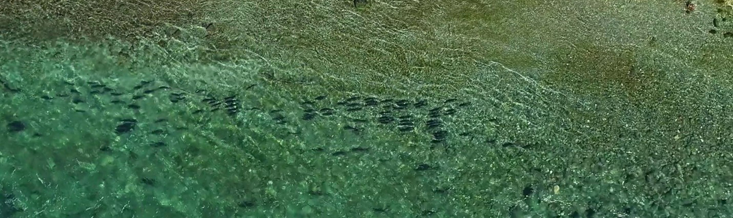
A field assessment in August 2024 was completed concurrent with a topographic site survey.The survey showed that Site 5, the most recently constructed gravel pad, had undergone the least degradation. This survey also showed that the most degradation was located across Site 7,the oldest gravel placement site that was surveyed. Since Site 7 is the oldest project site, the location would have experienced the greatest number of high flow events.
A spawning gravel field assessment was completed to identify the location and quality of available spawning gravel in the study reach. Results of this assessment showed that Site 5contained the highest quality spawning gravel and Site 7 contained the lowest quality. Site 9 had a greater percentage than Site 7 of unsuitable chinook spawning gravel across the original constructed gravel pad area. However, since the remaining spawning gravel at Site 9 is of greater quality than Site 7, a greater volume of gravel was mobilized from Site 7, and there is greater ease of access at Site 7, the next spawning gravel placement project is recommended to be at Site 7. The field assessment also identified areas of deposition outside of the spawning gravel pads.
Overall, Site 7 appeared to be the area most in need of supplemental spawning gravel.Information from the A-Tlegay report Utilization of Spawning Gravel by Chinook within the Campbell River 2024 (Appendix A) indicated the constructed spawning gravel sites were being utilized by salmonids. The report did not indicate a requirement for urgent gravel placement. Based on the results of the detailed assessment, it was recommended that a gravel placement project be undertaken by the end of summer, 2026. Site 7 was identified as the most likely location.